


Brantford History Bike Loop
43 km round trip—3 hours by bike
Start: Bell Homestead
Start with lunch or afternoon tea at the Bell Homestead, where Alexander Graham Bell invented the telephone. The tour passes by historic Salt Springs Church and the Mohawk Chapel. Take a short side trip to the Woodland Cultural Centre, housed in a former residential school and learn about Indigenous history and culture.
The tour is mainly on country roads and off-road multi-use trails. It includes 2 sections on busy highways, totalling about 4 km.
This ride is on the Haldimand Tract, which stretches 6 miles on either side of the Grand River from source to mouth, which was granted in perpetuity to the Six Nations for fighting for the British during the American Revolutionary War. Less than 5% of the original grant remains under the control of Six Nations today.
Link to Interactive Map of Brantford History Bike Loop
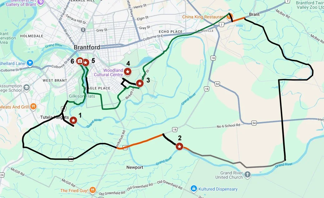
Park: Parking is available at the start of the ride, at the Bell Homestead (1), at the Royal Chapel of the Mohawks(3)and in front of the Earl Haig Family Fun Park (5), off Market St, in the centre of Brantford.
Park your car at the Bell Homestead (1), where Alexander Graham Bell lived with his parents when he first emigrated to Canada. Here he invented the telephone in 1874. Two years later, he made the world’s first “long distance” phone call to Paris, Ontario. Visit the museum and book a guided tour of the homestead. Start or finish your bike tour with a lunch or afternoon tea at the Exchange Café. Try their famous Apple Dapple cake and scones, or other baked goods and ice cream.
Turn R onto Tutela Heights Road (paved road) as you exit the Homestead and proceed to Mt Pleasant Rd (1 km). Turn L and ride for 2.5 km to Phelps Rd. Turn L onto Phelps Rd/Hwy 18 and continue for 4.5 km to the intersection with Cockshutt Rd. Continue on Hwy 18, but use caution after crossing Cockshutt Rd as it becomes a busy highway. Proceed across the bridge over the Grand River, which has narrow shoulders, to Salt Springs Church Rd (2.2 km).
Turn R onto Salt Springs Church Rd. You will pass Salt Springs Church in about 1 km. The church was founded in 1830 by William Ryerson (brother to Egerton Ryerson, a controversial colonial administrator, for whom Metropolitan University in Toronto was previously named) as a Methodist mission for the local Indigenous population. The current building was built in 1902. Behind the church is a graveyard where many settlers are buried, including William Ryerson.
Continue on Salt Springs Church Rd for 5 km. A short section immediately after the church has been partially washed out by the Grand River and is closed to vehicles. Use caution, especially during spring flooding and after heavy rain. and turn L onto Maclellan Rd (gravel road). In 2 km, the road crosses Highway 54, a very busy highway. Take care crossing the highway and continue for another 2 km on Campbell Rd (gravel road) to Old Onondaga Rd (paved country road) and turn R. In 1.6 km, take the L hand fork onto Brant School Rd (paved country road). This scenic road follows the course of Fairchild Creek, which is a tributary of the Grand River, crossing it several times. In 4.4 km, at the traffic lights, cross Colborne St E (busy highway) and turn L. Continue for 500 m on Colborne St E and turn R onto Papple Rd. In 400 m, the road crosses the Tom Longboat/Hamilton-Brantford Rail Trail (off-road multi-use trail). Turn L onto the trail. (If you turn R it follows the old Hamilton Brantford Railway route down the escarpment to Hamilton, a spectacular 28 km ride, which connects to the Great Lakes Waterfront Trail. Park a get-away car in Hamilton unless you want to ride uphill all the way up the escarpment!)
Today, we turn L onto the Tom Longboat Trail (named after Tom Longboat, who was the first Indigenous person to win the Boston Marathon, in 1907). Note the remnants of the Mohawk Canal, just before you reach Mohawk St. The canal was built in the 19th century for transportation of goods on barges, too large to travel on the Grand River. Like many canal systems, it was replaced by railroads in the later 19th century. Continue on the trail for 5.6 km to Royal Chapel of the Mohawks(3) The chapel was built in 1785, the first Anglican church in Upper Canada. It is the oldest surviving church in Ontario. The church was built by the British Crown and given to Six Nations in recognition of their services fighting for the British during the American Revolution. Joseph Brant, or Thayendanegea, a chief of the Mohawks (one of The Six Nations or Haudenosaunee), is buried here in a large tomb beside the chapel. The chapel, which is a National Historic Monument, is managed by Six Nations of the Grand River. The chapel is open to the public from Tuesday to Sunday, 10 am to 4 pm, during the summer.
After visiting the chapel, turn L onto Mohawk St in front of the chapel and continue 400 m to the Woodland Cultural Centre(4). Housed in the former Mohawk Institute Indian Residential School, it is now a centre for Indigenous language, culture, art and history. It is open daily from Monday to Saturday, and also offers tours and special exhibitions.
(History buffs may want to take a slight detour to the Canadian Military Heritage Museum. Continue on Mohawk St to Greenwich St (1 km) and turn R. The museum is in 1 km on the R on Greenwich St. Open Friday to Sunday, 12 pm to 4 pm from July and August, and Saturday and Sunday, 12 pm to 4 pm, March to June and September to November.) Return to the Woodland Cultural Centre on Mohawk St, and turn R onto 8th Ave. In 250 m, turn L onto Sanderson St. In 250 m, turn R onto the trail at the corner of 5th Ave and then R onto the Hamilton Brantford Rail Trail/Dike Trail.
Continue on the Hamilton Brantford Rail Trail/Dike Trail for another 2.6 km to River Rd (paved road with multi-use trail) and turn R. Ride the trail along the edge of the Grand River. In 800 m, the trail leaves the road and becomes the SC Johnson/Dike Trail. Continue for another 800 m. The Earl Haig Family Fun Park (5) is on the R. The water park is open daily in the summer. Cross the Grand River at the Plywood Patch Bridge (6). The plywood panels on the bridge have been turned into murals. Stop to admire the murals as well as great views of paddlers navigating the river. After crossing the bridge, turn L onto the Fordview Trail, which runs for 1.6 km, passing under Veterans Memorial Highway. This trail runs into the Gilkison Trail. Turn L and follow the trail along the river for 1.3 km to Mt Pleasant Rd (paved road). Turn L and continue 600 m back to Tutela Heights Road (paved road). Ride up the hill for 900 m back to the Bell Homestead (1).

Bell Homestead
